 |
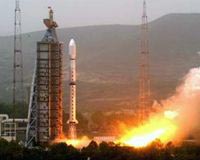
Taiyuan, China (XNA) May 28, 2008 China launched a second Olympic weather forecasting satellite, the Fengyun-3 (FY-3), Tuesday morning. The satellite was launched on a Long March-4C carrier rocket from the Taiyuan Satellite Launch Center in northern Shanxi Province at 11:02 a.m. (Beijing Time). It entered the preset orbit 27 minutes later. Gao Huoshan, general director of the FY-3 research team, said the satellite would send back images with the highest spatial resolution of 250 meters and its temperature sensitivity would reach 0.1 degree Fahrenheit. Both indices were close to the most advanced level of similar satellites in the world. The highest spatial resolution of existing satellites in China had been 1.1 kilometers, according to Gao. "The 250-m resolution images will be of vital significance for censoring global climate changes and possible subsequent natural disasters," said Gao. It would also contribute to key geographical data for the research on aviation, navigation, agriculture, forestry and oceanography, he added. The satellite was equipped with a dozen of advanced detectors such as the infrared scan actinograph and the microwave formatter. It is able to carry out a three-dimensional, all-weather, multi-spectrum quantitative detection to acquire data from the ground surface, the ocean and the space, according to sources with the China National Space Administration. Experts said the data collected by the satellite would not only facilitate weather forecast in China but also in other countries. China Meteorological Administration (CMA), in cooperation with Swedish meteorological authorities, had established a data collection terminal at the north pole to transmit data collected by the FY-3, according to an official with the National Satellite Meteorological Center (NSMC), which is affiliated with the CMA. The World Meteorological Organization had said it would use data offered by China's FY-3, Europe's METOP and U.S. NPOESS to detect changes of the atmosphere, the ocean and the ground surface, said the official. The 2,295-kilogram satellite will provide accurate and timely information about weather changes to facilitate more precise weather forecasts during the Beijing Olympic Games, said a CMA official earlier. The CMA official said the new satellite, with a bigger payload, would provide medium-range weather forecasts up to 10 to 15 days. Zheng Guoguang, director of the CMA, said the FY-3 would work with the existing FY-2 to ensure timely weather forecast during the Olympics. Both the satellite and the rocket are developed by the Shanghai Academy of Spaceflight Technology affiliated to the China Aerospace Science and Technology Corporation. The launch was the 106th mission of China's Long March series of rockets since April 24, 1970, when a Long March-1 rocket successfully sent China's first satellite Dongfanghong-1 into the space. China has launched eight meteorological satellites since research started in the 1970s. Its first Olympic weather forecasting satellite, the FY-2D, was launched towards the end of 2006. The CMA has identified weather forecast services for the Olympic Games as "a priority" for this year as the country may face much more frequent adverse weather. It has announced earlier that China will launch another 22 meteorological satellites by 2020, including four more from the Fengyun-2 series, 12 from the Fengyun-3 series and six from Fengyun-4 series. It would also contribute to key geographical data for the research on aviation, navigation, agriculture, forestry and oceanography, he added. The satellite was equipped with a dozen of advanced detectors such as the infrared scan actinograph and the microwave formatter. It is able to carry out a three-dimensional, all-weather, multi-spectrum quantitative detection to acquire data from the ground surface, the ocean and the space, according to sources with the China National Space Administration. Experts said the data collected by the satellite would not only facilitate weather forecast in China but also in other countries. China Meteorological Administration (CMA), in cooperation with Swedish meteorological authorities, had established a data collection terminal at the north pole to transmit data collected by the FY-3, according to an official with the National Satellite Meteorological Center (NSMC), which is affiliated with the CMA. The World Meteorological Organization had said it would use data offered by China's FY-3, Europe's METOP and U.S. NPOESS to detect changes of the atmosphere, the ocean and the ground surface, said the official. The 2,295-kilogram satellite will provide accurate and timely information about weather changes to facilitate more precise weather forecasts during the Beijing Olympic Games, said a CMA official earlier. The CMA official said the new satellite, with a bigger payload, would provide medium-range weather forecasts up to 10 to 15 days. Zheng Guoguang, director of the CMA, said the FY-3 would work with the existing FY-2 to ensure timely weather forecast during the Olympics. Both the satellite and the rocket are developed by the Shanghai Academy of Spaceflight Technology affiliated to the China Aerospace Science and Technology Corporation. The launch was the 106th mission of China's Long March series of rockets since April 24, 1970, when a Long March-1 rocket successfully sent China's first satellite Dongfanghong-1 into the space. China has launched eight meteorological satellites since research started in the 1970s. Its first Olympic weather forecasting satellite, the FY-2D, was launched towards the end of 2006. The CMA has identified weather forecast services for the Olympic Games as "a priority" for this year as the country may face much more frequent adverse weather. It has announced earlier that China will launch another 22 meteorological satellites by 2020, including four more from the Fengyun-2 series, 12 from the Fengyun-3 series and six from Fengyun-4 series.
Source: Xinhua News Agency
Source: Agence France-Presse Community Email This Article Comment On This Article Share This Article With Planet Earth
Related Links the missing link Earth Observation News - Suppiliers, Technology and Application
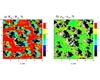 Richland WA (SPX) May 22, 2008
Satellites taking atmospheric measurements might now be able to see blue skies as clearly as optimists do. Researchers have found a way to reduce cloud-induced glare when satellites measure blue skies on cloudy days, by as much as ten-fold in some cases. |
|
| The content herein, unless otherwise known to be public domain, are Copyright 1995-2007 - SpaceDaily.AFP and UPI Wire Stories are copyright Agence France-Presse and United Press International. ESA Portal Reports are copyright European Space Agency. All NASA sourced material is public domain. Additional copyrights may apply in whole or part to other bona fide parties. Advertising does not imply endorsement,agreement or approval of any opinions, statements or information provided by SpaceDaily on any Web page published or hosted by SpaceDaily. Privacy Statement |
 del.icio.us
 Digg
Digg Reddit
 YahooMyWeb
 Google